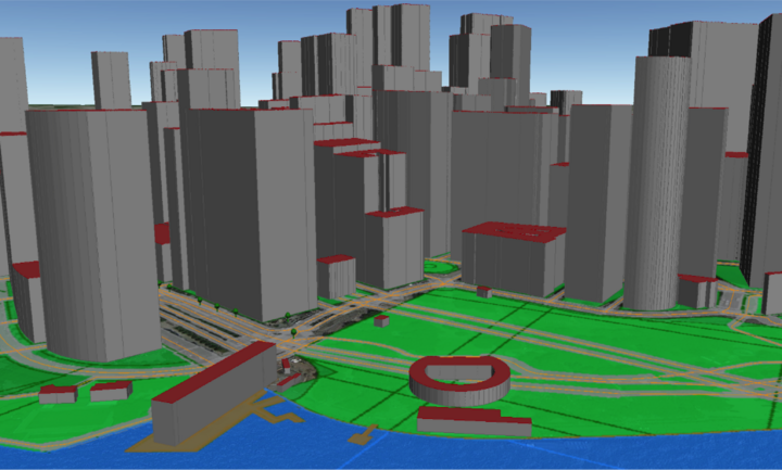
Our team at the Chair of Geoinformatics of Technische Universität München (TUM) has created and published a virtual 3D city model of New York City (NYC) that can freely be download from our project homepage. Also an Open Source 3D web viewer is provided allowing immediate interactive exploration and querying of the 3D model.
The city model is purely based on Open Data from the official Open Data Portal of NYC. 26 different datasets were integrated. From the 2D and 2.5D geospatial data around four million objects with 3D geometries were generated by a fully automated process. The resulting dataset covers the whole area from NYC and contains 3D buildings with addresses, streets, land lots, water bodies, parks, trees, and a triangulated digital terrain model. Most objects carry semantic information, because different thematic datasets from NYC administration were joined with the 3D model and their information was integrated. For example, most buildings carry information about the owner, construction year, residential area, commercial area, office are (all in sqm) etc. The 3D model is provided as a CityGML dataset in Level of Detail 1 (LOD1). The total datasize is around 1.6 TB of XML data (around 80GB compressed). At this moment the building models (> 1 million), streets (150,000), and land parcels (> 860,000) only are ready for download (around 12 GB of XML data).
CityGML is an international standard of the Open Geospatial Consortium (OGC) for the representation and exchange of semantic 3D city models. It is employed by many countries, states, and cities worldwide. CityGML can represent semantic information, 3D geometry, 3D topology, and graphical appearances for the most relevant types of city objects. Due to this capability it is increasingly being used in projects on urban simulations, Smart Cities, disaster management, urban planning, and energy planning.
The data transformation and integration processes have been developed in the context of the two master theses of Mrs Barbara Burger and Mrs Berit Cantzler at TUM. The implementation is based on the Feature Manipulation Engine (FME) from Safe Software and our Open Source geodatabase 3DCityDB running on Oracle Spatial 12c. A paper summarizing the work and the results has just been presented at the Photogrammetric Week 2015 in Stuttgart, Germany. It can be downloaded together with the datasets from the project website (see below).
Using 3DCityDB, a tiled KML model was exported that can be interactively explored in our new Open Source 3D Webclient for 3DCityDB. The Webclient extends the Open Source software Cesium Virtual Globe by means to manage large tiled 3D models in KML, object highlighting etc. The viewer has been developed by Zhihang Yao and Kanishk Chaturvedi, both being PhD students at the Chair of Geoinformatics @ TUM.
Links:
- Project homepage – https://www.lrg.tum.de/gis/projekte/3d-city-model-of-new-york-city/
- 3DCityDB – http://www.3dcitydb.net and https://github.com/3dcitydb
- 3DCityDB Webclient - https://github.com/3dcitydb/3dcitydb-web-map
- CityGML – http://www.citygml.org and http://www.opengeospatial.org/standards/citygml
