SRTM2gravity: a novel 3" global topographic gravity model (2018)
Summary
SRTM2gravity is a new 3" global model of gravity implied by Earth’s topographic masses. It represents a novel global data source for complete gravimetric terrain corrections suitable to reduce gravimetric surveys in geodesy and geophysics around the globe, or the creation of ultra-detailed gravity maps. The SRTM2gravity project is the first-ever successful attempt to compute and release the gravity field generated by the topography from the Shuttle Radar Topography Mission (SRTM) at 3” (about 90 m) spatial resolution globally.
Two main SRTM2gravity products have been developed: These are 1) full-scale gravity effects reflecting the total gravitational attraction of Earth’s global topography, and 2) residual (=short-scale = RTM) gravity effects containing short-wavelength gravitational signals only, at spatial scales less than ~10 km. The first product is equivalent to (complete) gravimetric terrain corrections. It contains both the linear gravity effect of the topography (known as Bouguer shell) as well as the non-linear effect (classically denoted as terrain correction in textbooks), so can be used to easily remove the topographic signal from observed gravity values. We have released our model at 3" resolution into the public domain for free use in science, teaching and by industry (http://ddfe.curtin.edu.au/models/SRTM2gravity2018 or https://ddfe.blazejbucha.com/models/SRTM2gravity2018/).
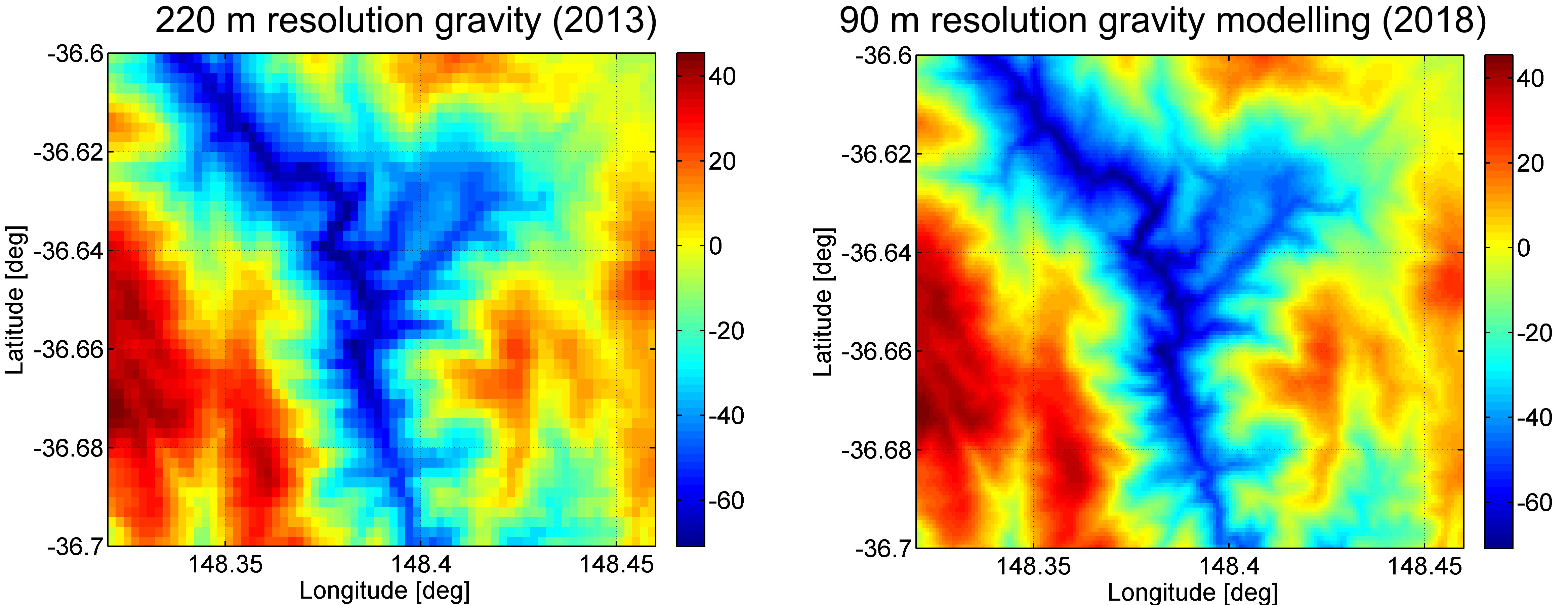
The SRTM2gravity model uniquely unites local resolution (3") with global coverage. SRTM2gravity conceptually improves over previous efforts, notably the 7.2" GGMplus gravity model, in three aspects: These are a) the use of more mature modelling techniques, b) the use of improved and cleaned topographic input data and c) ultra-fine 90 m instead of ~220 m detail, capable of better representing very short-scale terrain-induced gravity effects (Fig. 1).
Large-scale supercomputing resources facilitated SRTM2gravity
Given the number of computation points across Earth’s land and near-coastal areas (~27.9 billion at 90 m resolution within -60° and 90° latitude), and the need to evaluate Newton's integral at any of the computation points, our project faced of a major computational challenge. A solution became possible through the development of efficient modelling techniques, parallelization of the computation and use of advanced computational resources. The SRTM2gravity project was scaled to fit into the ~1,000,000 CPU-hour category. For the calculations, Bavaria’s SuperMUC supercomputing facility (www.lrz.de) was used. Using several 1000 CPUs in parallel, the computations were completed within only 8 weeks. They would have otherwise taken ~100 years on a desktop PC.
Input data
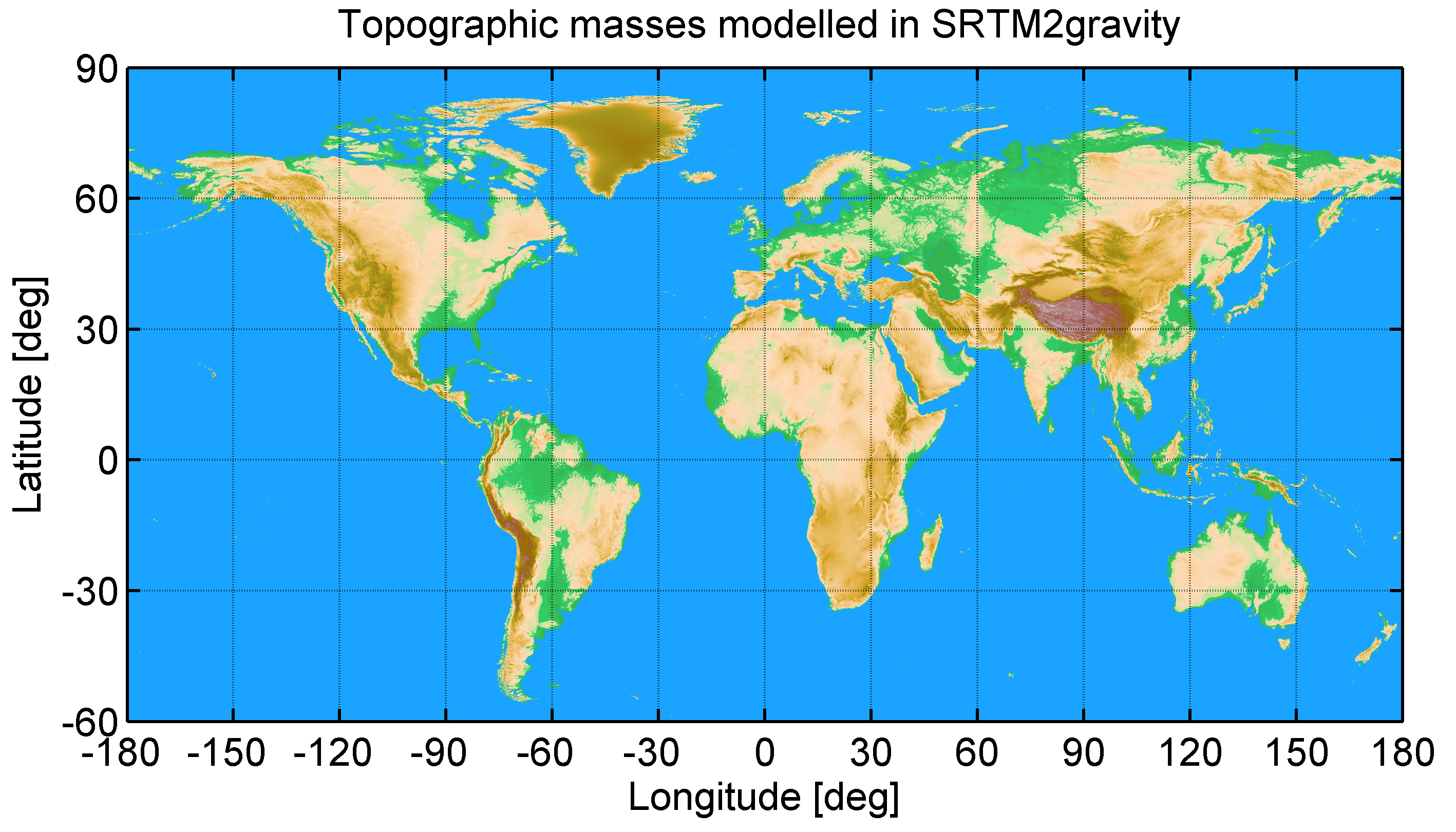
Key input data is the 3 arc-second resolution global v1.0.1 MERIT (Multi-Error-Removed Improved-Terrain) DEM (digital elevation model) data set by Yamazaki et al. (2017). The MERIT DEM primarily relies on SRTM (Shuttle Radar Topography Mission) version 2.1 data within ±60° latitude, and uses AW3D DEM data (ALOS/PRISM) north of 60° latitude. For the filling of SRTM voids (unobserved areas), DEM data collected and maintained by Viewfinder Panoramas was used. Together with a constant mass-density of 2670 kg m-3, MERIT is our representation for Earth’s topographic masses. In contrast to other DEM products, MERIT has been stripped of the tree canopy signal and further radar error sources as described in Yamazaki et al. (2017), so it represents – in good approximation – the bare ground. No attempt was made to model other mass-bodies or mass-density anomalies such as ocean or lake water, ice, or sediments. The MERIT-DEM represents the surface of water bodies (oceans or lakes) where present and the surface of ice masses where present. Users having detailed models of such mass-density models at hand are free to forward-model and subtract the effect from our SRTM2gravity values. A total of 120 locations with elevation outliers was detected with artefact screening techniques (Hirt 2018) and removed to further improve the terrain representation with the MERIT data set. The cleaned 3” MERIT DEM represents the detailed topographic mass model (Fig. 2) for the gravity forward modelling.
Methods and computational details
We have used a combination of mature and validated spectral and spatial-domain gravity forward modelling (GFM) techniques to take on the SRTM2gravity challenge. First, the 3” MERIT topographic surface was accurately expanded into a set of spherical harmonic coefficients to degree 2,160, representing the long- and medium-wavelengths of the topography to ~10 km (or ~300”) spatial scales. Second, ultra-high resolution spectral-domain GFM was used to calculate the gravitational field of the MERIT degree-2160 topography in spherical harmonics. Third, a residual terrain model (RTM) was formed as difference between the 3” MERIT topography and the MERIT degree-2,160 spherical harmonic topography, and converted to gravity effects via numerical integration techniques. Then, the total gravitational effect of the 3” MERIT topographic mass model follows as sum of results from step 2) and step 3).
As a main computational benefit of the adopted methodology, the integration could be restricted to ~40 km radius around the computation point, thus significantly reducing the total computation times compared to more tedious global evaluations (radius = ~20,000 km) of Newton’s integral over the 3” MERIT DEM. At ~28 billion computation points,
-
the spectral gravity forward modelling including synthesis of gravity effects at the 3D-surface required ~45,000 CPU-hours (4 %), and
-
the residual terrain modelling including the numerical integration within 40 km caps around each point required ~1,105,000 CPU-hours (96 % of total CPU time),
showing that the lion’s share of the computation time is associated with the detailed short-scale forward modelling in the spatial domain.
Results and products
The SRTM2gravity model comprises two different products:
-
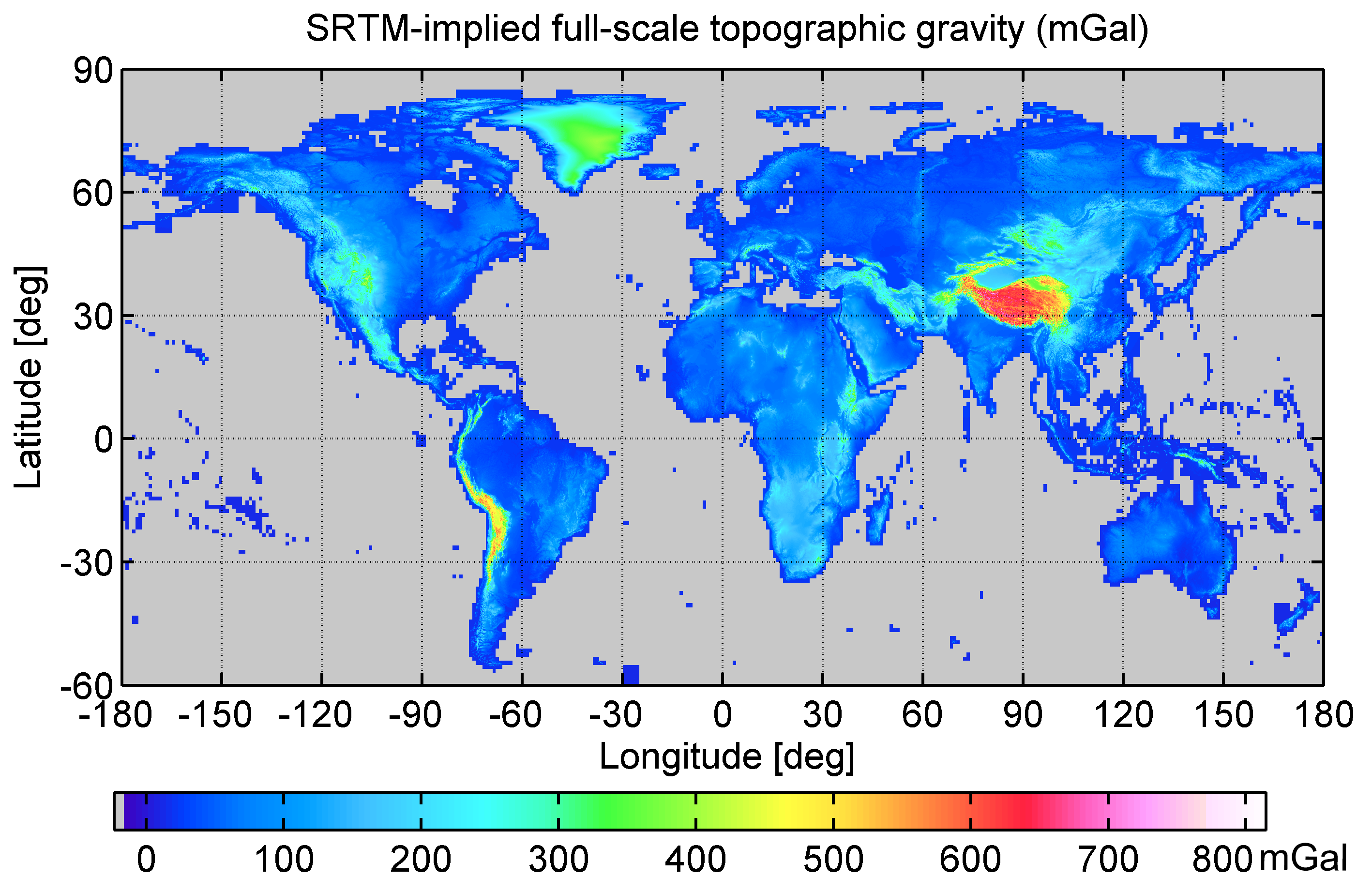
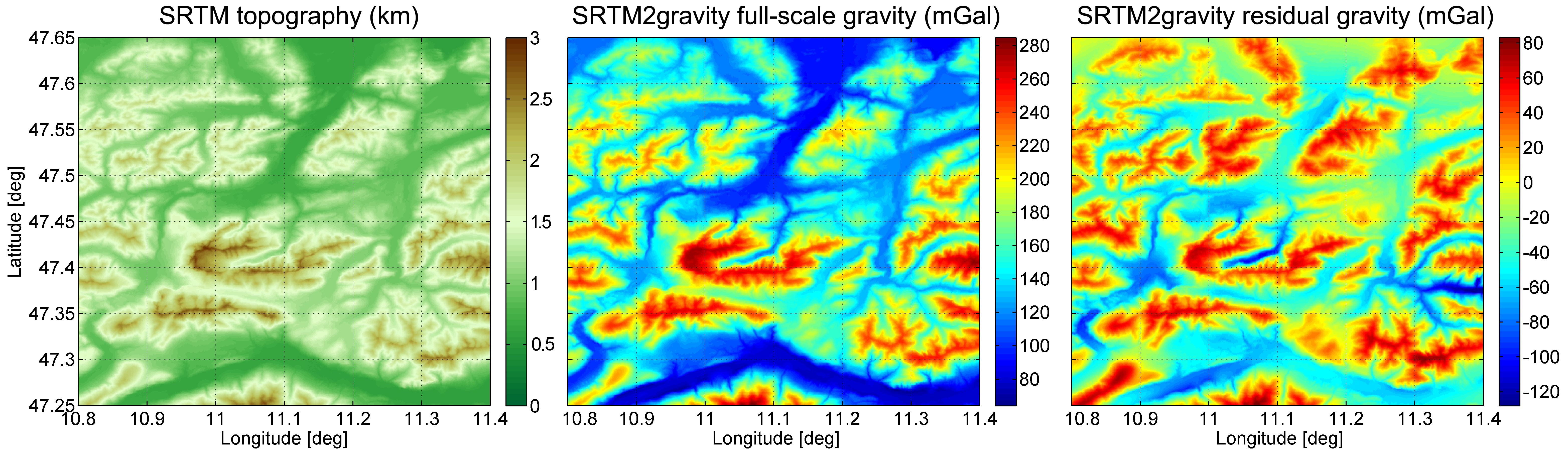
Gravimetric terrain corrections (full-scale gravity): The total gravity effect generated by the entire 3” MERIT topographic mass model, as can be obtained through a global numerical integration over all topographic mass elements. The full-scale gravity can be considered a modern kind of the gravimetric terrain correction: It contains both the gravity effect of a Bouguer shell and that of terrain irregularities (valleys, mountains) in form of a single product (Fig. 3).
-
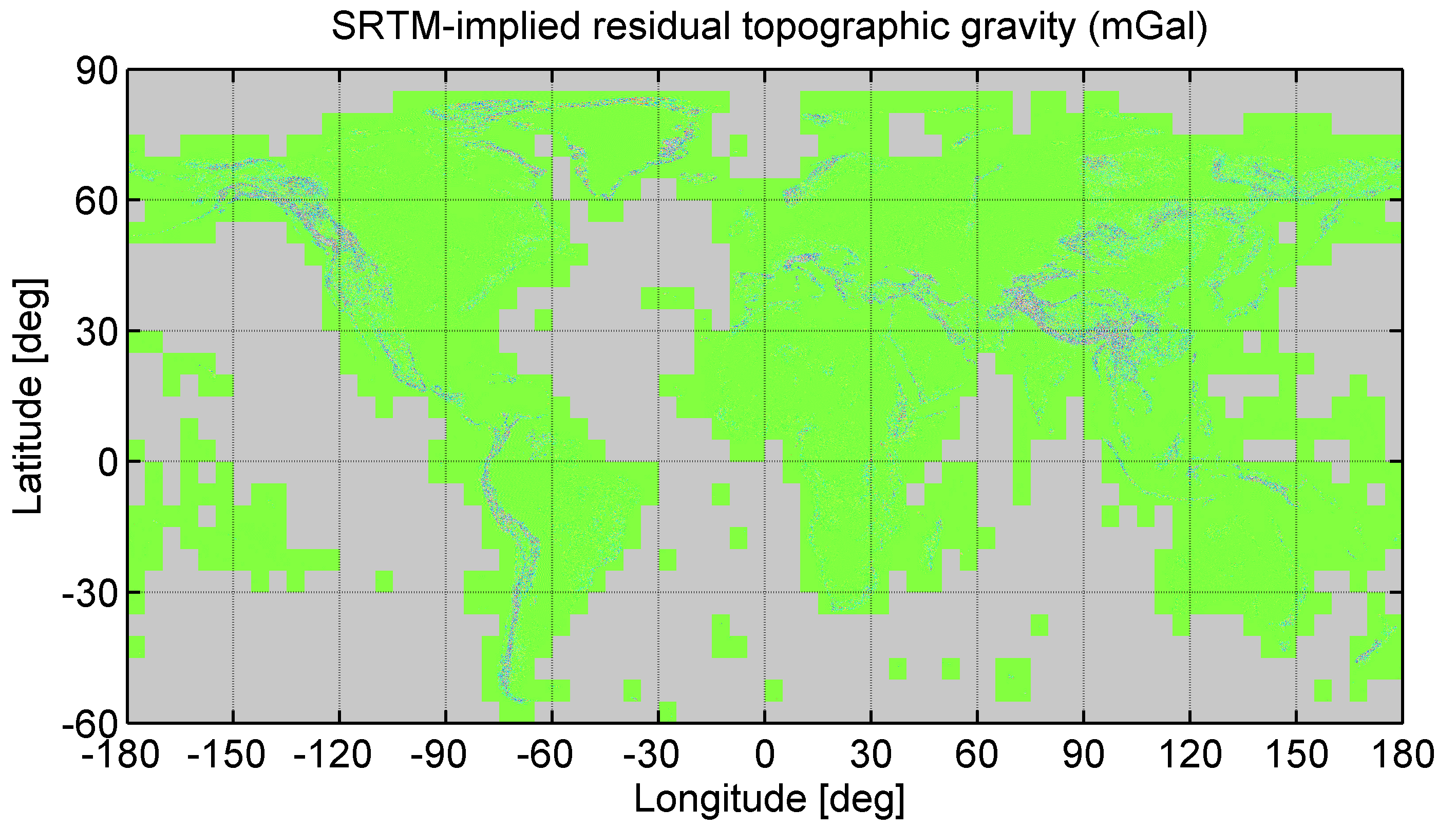
Residual (RTM) gravity: high-frequency gravity implied by the differences between 3” MERIT topographic mass model to the degree-2160 MERIT topography. This component, also known as RTM gravity in geodesy, contains short-scale gravitational signals with associated spatial scales of less than ~10 km, cf. Fig. 4. To improve the spectral characteristics of the RTM-gravity, short-scale spectral gravity signals with associated harmonic degrees of 2,161 up to 10,800 have been modelled and corrected (this is known as high-frequency correction to the RTM method, cf. Rexer et al. 2018).
The computation points cover – at 3” resolution – all of Earth’s land areas as represented by the MERIT topographic surface, excluding Antarctica. In coastal zones, computation points reside at the surface of the oceans. Fig. 5. compares both products – the full-scale and residual gravity over a small test area covering the German Zugspitze region to exemplify the detail resolution and signal characteristics.
Key applications
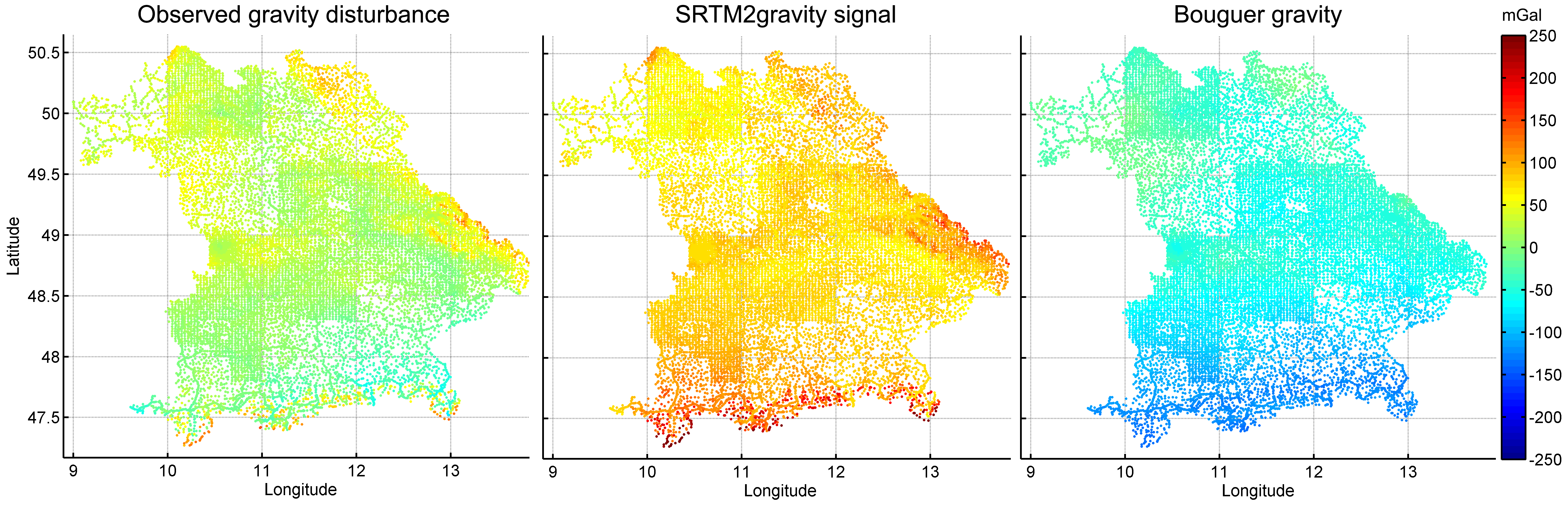
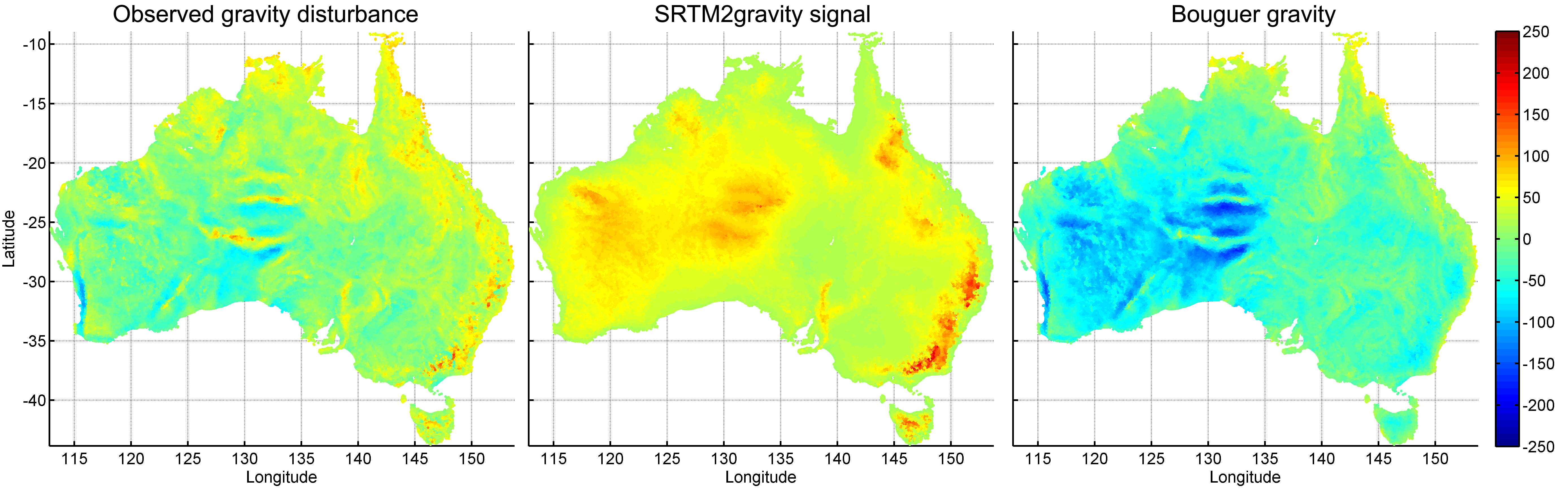
The full-scale gravity is readily usable as gravimetric terrain correction to gravimetric surveys in geodesy and geophysics (see Fig. 6 and Fig. 7 for examples). The residual gravity is suitable for short-scale augmentation (refinement) of Earth gravitation models such as EGM2008 (known as spectral enhancement technique in the literature), e.g., to create ultra-fine gravity maps.
Download and citation
The SRTM2gravity products are freely-available at 3” spatial resolution (~28 billion computation points). They are distributed in terms of 19,402 one-degree geographical tiles via the permanent repository
http://ddfe.curtin.edu.au/models/SRTM2gravity2018 (or its mirror site at: https://ddfe.blazejbucha.com/models/SRTM2gravity2018/)
Please refer to readme-files for further details on the data products, data formats and software tools, and known limitations of the model
http://ddfe.curtin.edu.au/models/SRTM2gravity2018/SRTM2gravity_Readme.dat
Citation:
Please acknowledge any use of the SRTM2gravity products by citing our paper
Hirt, C., M. Yang, M. Kuhn, B. Bucha, A. Kurzmann and R. Pail (2019), SRTM2gravity: an ultra-high resolution global model of gravimetric terrain corrections, Geophysical Research Letters 46, doi: 10.1029/2019GL082521. [PDF]
Acknowledgement
This work has been supported by German National Research Foundation (DFG) via grant Hi 1760/1, The Leibniz Rechenzentrum (LRZ) of the Bavarian Acadamy of Sciences and the TUM Institute for Advanced Study. All data providers are kindly acknowledged. Ground-truth data for the model validation has been kindly provided by various institutions (Landesamt für Digitalisierung, Breitband und Vermessung; Geoscience Australia, Swisstopo).
References
Hirt, C., M. Yang, M. Kuhn, B. Bucha, A. Kurzmann and R. Pail (2019), SRTM2gravity: an ultra-high resolution global model of gravimetric terrain corrections, Geophysical Research Letters 46, doi: 10.1029/2019GL082521. [PDF]
Hirt, C. (2018), Artefact detection in global digital elevation models (DEMs): The Maximum Slope Approach and its application for complete screening of the SRTM v4.1 and MERIT DEMs, Remote Sensing of Environment 207, 27-41, doi:10.1016/j.rse.2017.12.037.
Hirt, C., S.J. Claessens, T. Fecher, M. Kuhn, R. Pail, M. Rexer (2013), New ultra-high resolution picture of Earth's gravity field, Geophysical Research Letters, Vol 40, doi: 10.1002/grl.50838.
Rexer, M., C. Hirt, B. Bucha and S. Holmes (2018), Solution to the spectral filter problem of residual terrain modelling (RTM), Journal of Geodesy 92(6), 675-690, doi:10.1007/s00190-017-1086-y.
Yamazaki, D., D. Ikeshima, R. Tawatari, T. Yamaguchi, F. O’Loughlin, J.C. Neal, C.C. Sampson, S. Kanae, P.D. Bates (2017), A high accuracy map of global terrain elevations, Geophysical Research Letters, Doi:10.1002/2017GL072874.