Cities account for the largest share of total energy consumption. In addition to energy consumption for the manufacturing industry, high energy requirements for the heating or cooling of buildings, mobility (transport and logistics; individual transport) and artificial lighting are particularly relevant. However, energy is also generated in cities, for example in local power plants, through the utilization of process waste heat as well as through photovoltaic systems and solar thermal energy. Both, energy consumption and generation depend very specifically on the geographic location. Energy is distributed through complex and hierarchical network structures that extend over the entire urban area. Spatially related information and methods therefore play a central role in the investigation and further development of energy supply in cities.
In numerous projects, publications, dissertation projects, and graduation theses, the Chair of Geoinformatics investigates the specific requirements arising from the field of energy for geodata, data models and geoinformation systems, and which contributions geoinformatics and geoinformation can make. Geodata are already regularly used as source data for energy analyses and simulations. Increasingly, semantic 3D city models are being used to represent the relevant objects of urban space such as buildings, roads, water bodies, pipes and cables, etc. They are an ideal basis for the structured storage of and enrichment by energy related information and calculation results. The modelling, storage and simulation of energetic properties also play a role in the research areas City System Modelling and Smart Cities.
Research questions and topics that are examined at the Chair of Geoinformatics are among others:
What requirements do energetic simulations and analyses place on geoinformation?
How do geoinformation have to be structured (modeled) and what is the appropriate quality of the data such that it can be optimally used for energetic simulations and analyses?
How can existing data models and standards be extended accordingly?
To what extent can geoinformation systems and geodatabase management systems be used to store not only geodata but also associated energy data?
What changes and new concepts need to be added to GIS in order to accomplish the above mentioned tasks?
How can sensors such as smart meters, which measure current energy consumption in high temporal resolution, be integrated with geoinformation such as 3D building models?
Connection of stocks/flow network models with topographic, topological and functional modelling of utility networks
Visualization of energetic properties in 3D city models using 3D cartographic methods
We are also investigating how the structures and content of the geodata provided by the official authorities need to be further developed and supplemented in order to provide better answers to energy-related questions. To this end, the Chair of Geoinformatics is involved in international standardization bodies such as the Open Geospatial Consortium as well as in national standardization bodies such as the AdV (Working Committee of the Surveying Authorities of the Federal States of Germany) and the German Spatial Data Infrastructure GDI-DE.
Our team also played a major role in the conception and creation of the guideline on "3D GIS and Energy". The guide is offered by the Runde Tisch GIS e.V. (Round Table GIS association) for free download (only available in German language). It is not designed as a textbook, but as a handbook to stimulate the imagination of planners and decision-makers in the field of energy, to use 3D geo-information to find new solutions to their problems and to benefit from existing experience. Around 60 authors have compiled their knowledge in this guide. Scientists from the Technical University of Munich (TUM), the Stuttgart University of Applied Sciences (HfT) and the Swiss Federal Institute of Technology (ETH) Zurich, among others, report on their current application-oriented research and are supplemented by 18 practical examples in which GIS providers and energy suppliers present their respective projects.
Solar Potential Analysis
Building specific estimation of solar energy production
Since 2014, we have been developing methods for carrying out solar potential analyses on large semantic 3D city models at the Chair of Geoinformatics. This includes automated calibration, calculation performance as well as aggregation and visualization of results on different object levels. We are investigating how the results can be fed back to the 3D objects of the city model.
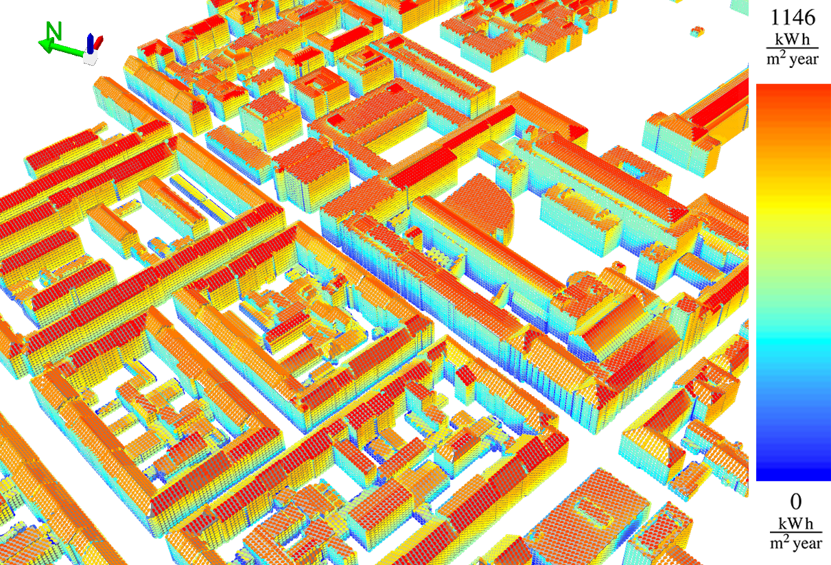
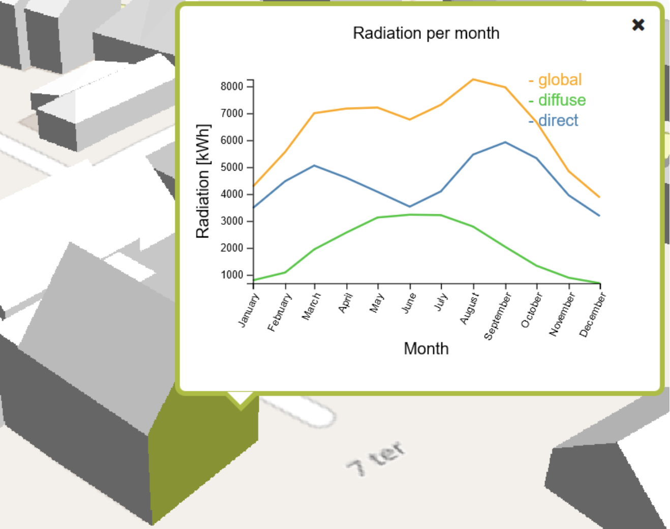
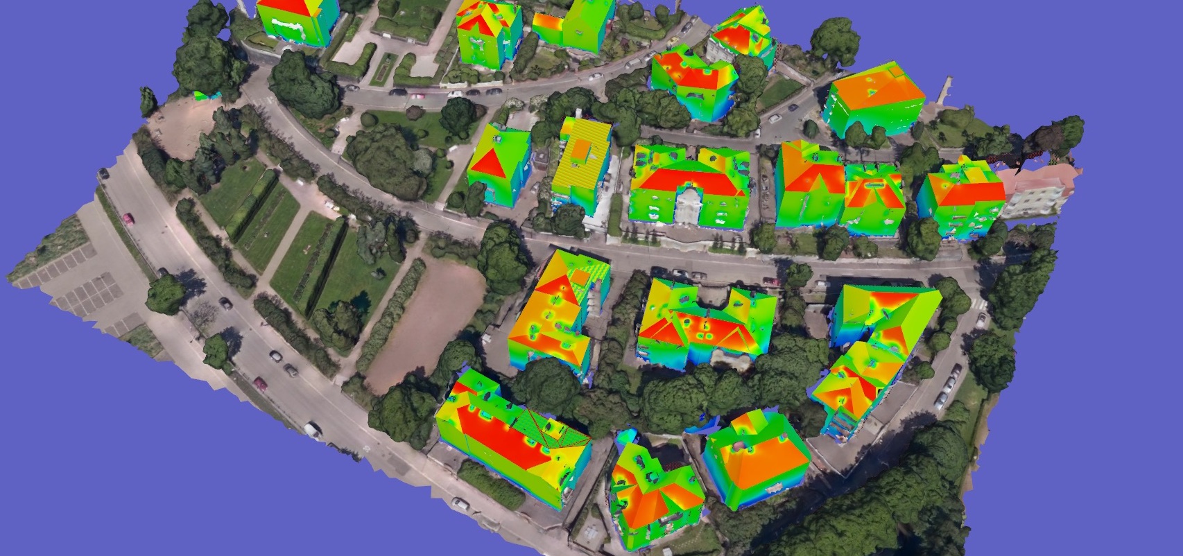
We have developed our own software tool for carrying out solar potential analyses for city districts and entire cities. On the basis of 3D city models in CityGML it calculates the solar irradiation energy on the 3D objects and augments the city model by the calculation results. For this purpose, the irradiation values on each individual object surface (for buildings, the roof and wall surfaces) are calculated at regular time intervals (e.g. every five minutes) for a whole year, taking into account the respective position of the sun and shading. In contrast to many other programs for solar potential analysis, which are based on 2.5D digital surface models (e.g. from point clouds from laser scanning or stereo photogrammetry), all objects are represented in 3D and the irradiation values on vertical surfaces and under roof overhangs are calculated correctly. In general, the direct radiation as well as the diffuse radiation are considered. The irradiation values can be aggregated arbitrarily according to time intervals and surface classifications (e.g. the monthly sum of the global radiation of all walls of each building). The solar tool is calibrated with remote sensing data for the respective location. A detailed validation with pyranometer measurements in Potsdam and Freising shows a high accuracy of the estimates.
Our solar tool has already been used to carry out solar potential analyses for the city of Helsinki, the London Borough of Barking and Dagenham, the city of Rennes and for parts of Munich, Berlin and Utrecht. The official solar atlas of the city of Helsinki is based on the calculation results. As part of the OGC Future Cities Pilot project it was shown how the time-dependent irradiation data (time series) on the individual building surfaces and the entire building objects can be assigned to the objects and exchanged using the CityGML Dynamizer ADE.
At the Chair of Geoinformatics we are currently investigating how the increasingly widespread 2.8D mesh city models used by Google Maps, Apple Maps, Bentley Reality Modeling and others can be used to increase the estimation accuracy of solar potential analysis. Although the mesh models contain only geometric and radiometric information and no semantics, they have a high geometric resolution. Since such models can be obtained fully automatically on the basis of laser scanning or photogrammetric acquisition methods, they can also be updated frequently. We are working on methods matching those parts of the mesh model that correspond to objects of the semantic 3D city model. In this way, objects which are not represented in the semantic model, such as vegetation objects, billboards or poles, but which cast shadows on object surfaces in reality, can still be taken into account in the solar potential analysis.
Estimation of different energy requirements with semantic 3D city models
Since 2009 we have been investigating the role semantic 3D city models can play in estimating the energy requirements of buildings in cities. From the very beginning, we have focused on a building specific approach, i.e. the estimation of energy needs for heating, cooling, hot water and electricity for every single building in a city (or village). The special challenges are the consideration of the building type and its use, the specific physical status (e.g. materials, state of refurbishment), the geographic location, the shape as well as the solar exposure. Since often specific information e.g. about building materials used or the number of occupants of a house or apartment is not available for all buildings, we have also investigated how these can be derived using spatial and statistical methods.
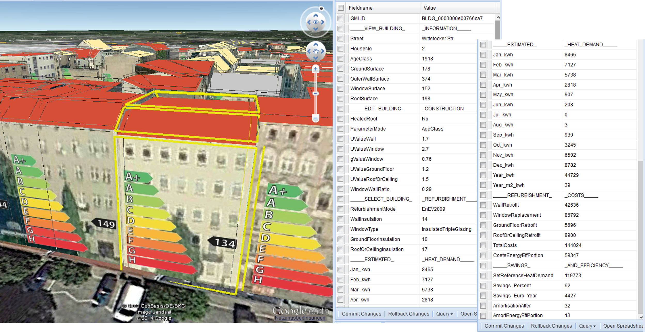
We have developed and implemented methods to carry out precise estimations of energy requirements for the actual state of buildings on the basis of German (DIN) standard 18599-2 and ISO standard 13790. The methods were implemented as independent analysis modules as well as interactive web applications and work directly on 3D city models in the CityGML scheme or on the 3D geodatabase 3DCityDB. An important calculated characteristic value is the heating energy demand per square meter of usable floor space per year, which must also be shown in the energy performance certificate of each building. The interactive web application allows performing "what if" scenarios. Buildings can be virtually refurbished in the web browser, whereby the possible energy savings and expected costs are estimated. The tools have already been used for parts of Berlin (see EIT Climate-KIC project Energieatlas Berlin), parts of London as well as for the Bavarian communities of Poing and Pullach. In all cases the estimates were validated against real consumption data. The tools are used in particular for strategic energy planning, because they also make it possible to calculate the energy consumption of larger areas, e.g. entire neighbourhoods. For example, conclusions can be drawn as to whether the energy requirement can be reduced to such an extent that the district can be supplied by a combined heat and power plant or by geothermal energy.
In particular, we are working on the extension of existing data models such as CityGML and geo databases such as the 3DCityDB for 3D city models to include properties and object types required for energy analyses and the storage of their results. Technical extensions of the CityGML standard (so-called Application Domain Extensions, ADEs) comprise:
CityGML Energy ADE - enrichment of building models with specific attributes and objects that are required for comprehensive energy simulations down to the level of individual zones or rooms;
CityGML UtilityNetwork ADE - topographic and functional modelling of supply and disposal networks as well as telecommunication networks;
CityGML Dynamizer ADE - representation of dynamic data (time series such as energy consumption) and coupling with sensors such as smart meters or temperature sensors.
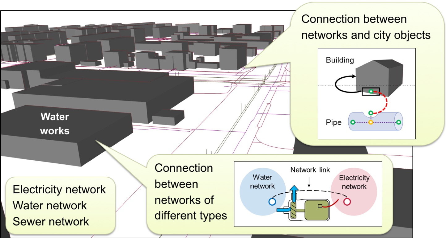
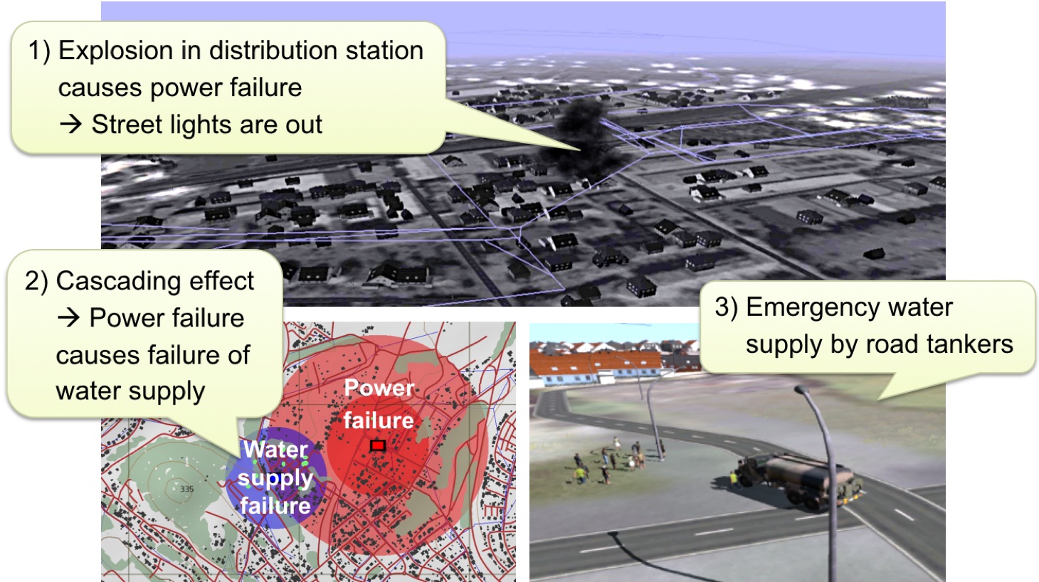
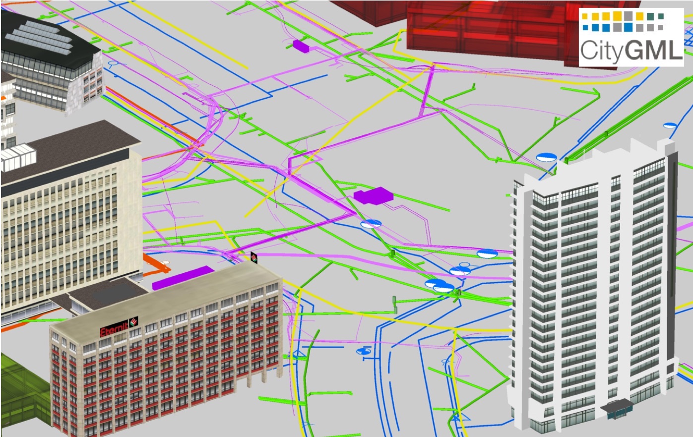
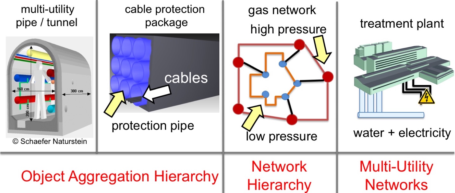
Energy is distributed via networks that extend across regions. This involves the connection and distribution of electricity, gas and district heating. However, other networks such as fresh water supply and wastewater disposal as well as telecommunications networks also play an important role in urban life and the functioning of energy supply. We have been working on semantic 3D modelling, storage, analysis and visualisation of coupled supply and disposal networks since 2008. In several projects we have developed data models for the topographic and functional representation of multi utility networks. Based on these models, methods for the analysis of networks and their vulnerabilities have been developed. Simulation methods for the determination of cascading effects in case of failure of infrastructure components were realized. By coupling with other objects from 3D city models, e.g. the buildings, conclusions can be drawn about the number and type of affected facilities and persons. For the results of the BMBF-funded research project SIMKAS 3D - Simulation of intersectoral cascading effects in case of failures of supply infrastructures using the virtual 3D city model of Berlin - we were awarded together with the project partners with the GIS Best Practice Award 2013 of the DVW - Gesellschaft für Geodäsie, Geoinformation und Landmanagement e.V. (Society for Geodesy, Geoinformation and Land Management).
The developed concepts are implemented under the name CityGML Utility Network ADE as a thematic extension of the CityGML standard by modelling and 3D representation of supply and disposal networks. The simultaneous and coupled modelling of different types of networks for e.g. electricity, gas, district heating, telecommunications, fresh water and waste water is supported. Functional dependencies between components of different networks can be explicitly represented and used for simulations of failures and their cascading effects. The hierarchical representation of networks (e.g. high, medium and low voltage networks) is also possible.
Each network component is mapped topographically as a 3D object as well as with its functional aspects including the network topology. This enables 3D visualization, monitoring and comprehensive analyses of supply and disposal networks. The generation of data for coupled network models as well as the automated derivation of simulator data for training simulators have also been the subject of previous research. For the CityGML UtilityNetwork ADE, the data models, the XML application schema and test data from Canada and the Netherlands are available on the Internet (see links below).
Bachert, Carolin; León-Sánchez, Camilo; Kutzner, Tatjana; Agugiaro, Giorgio: Mapping the CityGML Energy ADE to CityGML 3.0 Using a Model-Driven Approach. ISPRS International Journal of Geo-Information 13 (4), 2024, 121 more…BibTeX
2023
Bachert, Carolin: Mapping the Energy ADE to CityGML 3.0. Master thesis, 2023 more…BibTeX
Faltermeier, Florian L.; Krapf, Sebastian; Willenborg, Bruno; Kolbe, Thomas H.: Improving Semantic Segmentation of Roof Segments Using Large-Scale Datasets Derived from 3D City Models and High-Resolution Aerial Imagery. Remote Sensing 15 (17), 2023 more…BibTeX
Harter, Hannes; Willenborg, Bruno; Lang, Werner; Kolbe, Thomas H.: Climate-neutral municipal building stock - life cycle assessment of large residential building stocks based on semantic 3D city models. Energy and Buildings 292 (113141), 2023 more…BibTeX
Harter, Hannes; Willenborg, Bruno; Lang, Werner; Kolbe, Thomas H.: Life Cycle Assessment of building energy systems on neighbourhood level based on semantic 3D city models. Journal of Cleaner Production 407 (137164), 2023 more…BibTeX
Faltermeier, Florian: Improving CNN roof segment detection by dataset extension using 3D city models. Projekt thesis, 2022 more…BibTeX
Knoll, Kevin: Zusammenführung von Luftbild- und 3D-basierter Photovoltaik-Potenzialanalyse. Master thesis, 2022 more…BibTeX
Krapf, Sebastian; Willenborg, Bruno; Knoll, Kevin; Bruhse, Matthias; Kolbe, Thomas H.: Deep Learning for Semantic 3D City Model Extension: Modeling Roof Superstructures using Aerial Images for Solar Potential Analysis. ISPRS Annals of the Photogrammetry, Remote Sensing and Spatial Information Sciences (ISPRS Annals of the Photogrammetry, Remote Sensing and Spatial Information Sciences), 2022 more…BibTeX
2021
Harter, Hannes; Willenborg, Bruno; Schneider-Marin, Patricia; Banihashemi, Farzan; Vollmer, Michael; Kierdorf, Daniel; Kolbe, Thomas H.; Lang, Werner: Uncertainty Analysis of Life Cycle Assessment Input Parameters on City Quarter Level. Building Simulation 2021, 2021 more…BibTeX
Sedlmeier, P.: Extending the Calibration of the Transition Model for Calculating Solar Radiation Values. IDP-Arbeit, 2021 more…BibTeX
2020
Besinger, Leander: Solarpotentialanalyse auf Basis von 3D-Stadtmodellen – Performance und Ergebnisqualität. Bachelor thesis, 2020 more…BibTeX
Harter, H.; Willenborg, B.; Lang, W.; Kolbe, T. H.: Life Cycle Assessment of Technical Building Services of Large Residential Building Stocks using Semantic 3D City Models. ISPRS Annals of Photogrammetry, Remote Sensing and Spatial Information Sciences VI-4/W1-2020, 2020, 85-92 more…BibTeX
2018
Elfouly, Mostafa; Donaubauer, Andreas; Kolbe, Thomas H.: Prediction of feed-in power from photovoltaics in local distribution networks. PFGK18 - Photogrammetrie - Fernerkundung - Geoinformatik - Kartographie, 37. Jahrestagung in München 2018 (Publikationen der Deutschen Gesellschaft für Photogrammetrie, Fernerkundung und Geoinformation e.V. 27), Deutsche Gesellschaft für Photogrammetrie, Fernerkundung und Geoinformation e.V., 2018, 199-212 more…BibTeX
Fuchs, Dominik: Berechnung des Energiebedarfs von Wohngebäuden auf Basis von semantischen 3D-Stadtmodellen am Beispiel der Gemeinde Poing. Bachelor thesis, 2018 more…BibTeX
Kutzner, Tatjana; Hijazi, Ihab; Kolbe, Thomas H.: Semantic Modelling of 3D Multi-utility Networks for Urban Analyses and Simulations – The CityGML Utility Network ADE. International Journal of 3-D Information Modeling (IJ3DIM) 7 (2), 2018, 1-34 more…BibTeX
Willenborg, Bruno; Pültz, Martin; Kolbe, Thomas H.: Integration of Semantic 3D City Models and 3D Mesh Models for Accuracy Improvements of Solar Potential Analyses. Proceedings of the 13th International 3D GeoInfo Conference 2018 (ISPRS Archives of the Photogrammetry, Remote Sensing and Spatial Information Sciences), ISPRS, 2018, 223-230 more…BibTeX
2017
Chaturvedi, Kanishk; Willenborg, Bruno; Sindram, Maximilian; Kolbe, Thomas H.: Solar Potential Analysis and Integration of the Time-dependent Simulation Results for Semantic 3D City Models Using Dynamizers. Proceedings of the 12th International 3D GeoInfo Conference 2017 (ISPRS Annals of the Photogrammetry, Remote Sensing and Spatial Information Sciences), ISPRS, 2017, 25-32 more…BibTeX
Hijazi, Ihab; Kutzner, Tatjana; Kolbe, Thomas H.: Use Cases and their Requirements on the Semantic Modeling of 3D Supply and Disposal Networks. Kulturelles Erbe erfassen und bewahren - Von der Dokumentation zum virtuellen Rundgang, 37. Wissenschaftlich-Technische Jahrestagung der DGPF (Publikationen der Deutschen Gesellschaft für Photogrammetrie, Fernerkundung und Geoinformation (DGPF) e.V.), Deutsche Gesellschaft für Photogrammetrie, Fernerkundung und Geoinformation e.V., 2017, 288-301 more…BibTeX
Huang, Jingsui: Assessing the Potential of Rooftop Photovoltaics in Greater Cairo, Egypt Using Two GIS-based Approaches (ArcGIS Model and CityGML): A Case Study of Al Rehab. Master thesis, 2017 more…BibTeX
Willenborg, Bruno; Sindram, Maximilian; Kolbe, Thomas H.: Applications of 3D City Models for a better understanding of the Built Environment. In: Behnisch, Martin; Meinel, Gotthard (Ed.): Trends in Spatial Analysis and Modelling. Springer International Publishing, 2017, 167-191 more…BibTeX
2016
Eberle, Benjamin Tim: Validierung von geschätzten Sonneneinstrahlungswerten anhand von Messdaten des Deutschen Wetterdienstes für die Standorte Potsdam und Weihenstephan. Bachelor thesis, 2016 more…BibTeX
Kausika, Bhavya; Moshrefzadeh, Mandana; Kolbe, Thomas H.; van Sark, Wilfried: 3D Solar Potential Modelling and Analysis: A case study for the city of Utrecht. 32nd European Photovoltaic Solar Energy Conference and Exhibition, EUPVSEC 2016, 2016 more…BibTeX
Kreuzpaintner, David: Texturgenerierung aus Punktrastern für 3D-Gebäudemodelle. Bachelor thesis, 2016 more…BibTeX
Nguyen, Son H.: Model-driven General Indicator Modelling exemplified by the Building Thermal Energy Assessment Standard DIN 18599-2. IDP-Arbeit, 2016 more…BibTeX
2015
Willkomm, Philipp; Kaden, Robert; Coors, Volker; Kolbe, Thomas H. (Ed.): Leitfaden 3D-GIS und Energie. Runder Tisch GIS e.V., 2015 more…BibTeX
Kaden, Robert; Elfouly, Mostafa; Kolbe, T.H.: The CityGML Energy ADE - An International Standardization Effort for the Extension of 3D City Models to Support Energetic Building Analysis. Innovations for Energy Systems, Mobility, Buildings and Materials, printy - Digitaldruck & Kopierservice, 20155th Energy Colloquium of the Munich School of Engineeringmore…BibTeX
Nouvel, Romain; Bahu, Jean-Marie; Kaden, Robert; Kaempf, Jerome; Cipriano, Piergiorgio; Lauster, Moritz; Häfele, Karl-Heinz; Munoz, Esteban; Tournaire, Olivier; Casper, Egbert: Development of the CityGML Application Domain Extension Energy for Urban Energy Simulation. Building Simulation 2015 - 14th Conference of the International Building Performance Simulation Association, 2015, 559-564 more…BibTeX
Nouvel, Romain; Kaden, Robert; Bahu, Jean-Marie; Kaempf, Jerome; Cipriano, Piergiorgio; Lauster, Moritz; Benner, Joachim; Munoz, Esteban; Tournaire, Olivier; Casper, Egbert: Genesis of the CityGML Energy ADE. Proceedings of International Conference CISBAT 2015 on Future Buildings and Districts Sustainability from Nano to Urban Scale, LESO-PB, EPFL, 2015, 931-936 more…BibTeX
Zahn, Wolfgang: Sonneneinstrahlungsanalyse auf und Informationsanreicherung von großen 3D-Stadtmodellen im CityGML-Schema. Master thesis, 2015 more…BibTeX
Zirak, Maryam: A Model-driven Approach for Linking Building Thermal Energy Assessment Standards and the CityGML Energy Application Domain Extension (ADE) using UML. Master thesis, 2015 more…BibTeX
2014
Bartels, Marie; Becker, Thomas; Hahne, Michael; Hempel, Leon; Kolbe, Thomas H.; Lieb, Renate: Simulation von Kaskadeneffekten beim Ausfall von Infrastrukturen. zfv - Zeitschrift für Geodäsie, Geoinformation und Landmanagement (4), 2014, 217-223 more…BibTeX
Casper, Egbert; Häfele, Karl-Heinz; Kaden, Robert: OGC standard CityGML opens up new applications in energy simulation. Journal of the National Institute of Building Sciences 2 (6), 2014, 30-32 more…BibTeX
Kaden, Robert; Kolbe, Thomas H.: Simulation-Based Total Energy Demand Estimation of Buildings using Semantic 3D City Models. International Journal of 3-D Information Modeling 3 (2), 2014, 35-53 more…BibTeX
Offer, Julia; Kaden, Robert; Kastner, Oliver; Zimmermann, Günter; Kolbe, Thomas H.: Entwicklung eines GIS-Werkzeugs zur Untersuchung geothermischer Energieproduktionspotenziale. Angewandte Geoinformatik 2014, Wichmann Verlag, 2014Tagungsband zur Konferenz AGIT 2014, 127-136 more…BibTeX
Yao, Zhihang; Sindram, Maximilian; Kaden, Robert; Kolbe, Thomas H.: Cloud-basierter 3D-Webclient zur kollaborativen Planung energetischer Maßnahmen am Beispiel von Berlin und London. In: Kolbe, Thomas H.; Bill, Ralf; Donaubauer, Andreas (Ed.): Geoinformationssysteme 2014. Wichmann, 2014 more…BibTeX
2013
Banfi, Daniel: Energiebedarfsanalyse urbaner Räume anhand des semantischen Modells und Austauschformats CityGML. Master thesis, 2013 more…BibTeX
Becker, Thomas; Nagel, Claus; Kolbe, Thomas H.: Semantic 3D modeling of multi-utility networks in cities for analysis and 3D visualization. In: Pouliot, Jacynthe; Daniel, Sylvie; Hubert, Frédéric; Zamyadi, Alborz (Ed.): Progress and New Trends in 3D Geoinformation Sciences. Springer, 2013, 41-62 more…BibTeX
Biernath, Felix: Berechnung der Wärmeenergiebedarfe von Gebäuden und deren Validierung anhand tatsächlicher Verbrauchsdaten. Bachelor thesis, 2013 more…BibTeX
Kaden, Robert; Kolbe, Thomas H.: City-Wide Total Energy Demand Estimation of Buildings using Semantic 3D City Models and Statistical Data. Proc. of the 8th International 3D GeoInfo Conference, 2013 more…BibTeX
Kaden, Robert; Nagel, Claus; Herreruela, Javier; Kolbe, Thomas H.: Kopplung von 3D-Stadtmodellen mit Cloud-Diensten. Neue Horizonte für Geodateninfrastrukturen – Open GeoData, Mobility, 3D-Stadt, 2013 more…BibTeX
Kaden, Robert; Prytula, Michael; Krüger, Andreas; Kolbe, Thomas H.: Energieatlas Berlin: Vom Gebäude zur Stadt – Am Beispiel zur Abschätzung der Wärmeenergiebedarfe von Gebäuden. Geoinformationssysteme 2013 - Beiträge zum 18. Münchner Fortbildungsseminar Geoinformationssysteme, 2013, 17-32 more…BibTeX
Kastner, Oliver; Huenges, Ernst; Bredel-Schürmann, Stefan; Kolbe, Thomas H.; Kabus, Frank: Geothermische Wärmeversorgung von Metropolen aus dem Tiefengestein am Beispiel Berlins. Zusammenarbeit von Forschung und Wirtschaft für Erneuerbare Energien und Energieeffizienz - Beiträge zur FVEE-Jahrestagung 2012, ForschungsVerbund Erneuerbare Energie (FVEE), 2013 more…BibTeX
2012
Kaden, Robert; Krüger, Andreas; Kolbe, Thomas H.: Energy Atlas Berlin. 2012 more…BibTeX
Kaden, Robert; Krüger, Andreas; Kolbe, Thomas H.: Integratives Entscheidungswerkzeug für die ganzheitliche Planung in Städten auf der Basis von semantischen 3D-Stadtmodellen am Beispiel des Energieatlasses Berlin. Tagungsband der Wissenschaftlich-Technischen Jahrestagung der Deutschen Gesellschaft für Photogrammetrie, Fernerkundung und Geoinformation (DGPF) in Potsdam, 2012 (Publikationen der Deutschen Gesellschaft für Photogrammetrie, Fernerkundung und Geoinformation (DGPF) e.V.), 2012 more…BibTeX
Krüger, Andreas; Kolbe, Thomas H.: Building Analysis for Urban Energy Planning Using Key Indicators on Virtual 3D City Models: The Energy Atlas of Berlin. Proceedings of the ISPRS Congress 2012 in Melbourne (ISPRS International Archives of the Photogrammetry, Remote Sensing and Spatial Information Sciences), ISPRS, 2012 more…BibTeX
Sindram, Maximilian; Zimmer, Markus: Die Zukunft der Energiemärkte – Ein GIS-gestützter Ansatz. Geoinformationssysteme – Beiträge zum 17. Münchner Fortbildungsseminar 2012, Wichmann, 2012, 283-289 more…BibTeX
2011
Becker, Thomas; Nagel, Claus; Kolbe, Thomas H.: Integrated 3D Modeling of Multi-utility Networks and Their Interdependencies for Critical Infrastructure Analysis. In: Advances in 3D Geo-Information Sciences. Springer, 2011, 1--20 more…BibTeX
2010
Carrión, Daniel; Lorenz, Alexandra; Kolbe, Thomas H.: Estimation of the energetic rehabilitation state of buildings for the city of Berlin using a 3D city model represented in CityGML. ISPRS Conference: International Conference on 3D Geoinformation. XXXVIII-4, ISPRS, 2010 more…BibTeX