Projects
The Chair of Geoinformatics is involved in a broad range of research projects which are presented on this page. More information on each project is provided on the individual project pages.
Smart District Data Infrastructure (SDDI)
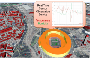
More than 50% of the world population is living in cities today and the number is further increasing. No matter if looking at environmental noise, air quality and particulate matter, energy usage and production, or traffic flows - in order to achieve or maintain a high quality of living in cities, municipalities and companies must take into account many different concerns simultaneously. The concept "Smart District Data Infrastructure" (SDDI) provides planners with the necessary set of flexible tools. Entire cities or just city districts are represented by 3D virtual city models which are linked with dynamic data, for example, on the traffic density or energy consumption. These models are used for monitoring and evaluation of the current situation, and especially for simulations of future developments and an early impact analysis.

As one of 100 winners from about 1000 candidates the project has been awarded "Landmarks in the Land of Ideas" 2016. The goal of the "Germany – Land of Ideas" initiative and Deutsche Bank is to make innovations visible in Germany and abroad and to strengthen the economic potential and sustainability of Germany as a location. This year, in 2016, the competition "CommUnityInnovation – a model for success" is awarding projects that show the added value and potential of joint action, whether in business partnering, scientific networks, or neighbourhood initiatives. [more...]
3D City Database
The award winning 3D City Database (3DCityDB) is a free 3D geo database to store, represent, and manage virtual 3D city models on top of a standard spatial relational database. The database model contains semantically rich, hierarchically structured, multi-scale urban objects facilitating complex GIS modeling and analysis tasks, far beyond visualization. The 3D City Database comes with additional software providing easy data exchange or facilitating coupling with cloud services. The 3D City Database content can be directly exported in KML, COLLADA, and glTF formats for the visualisation in a broad range of applications like Cesium WebGL, Google Earth, ArcGIS and ArcGIS Explorer. [mehr...]
3D City Model of New York City
In this student project a semantic 3D city model of New York City (NYC) has been created based on datasets provided in the NYC Open Data Portal. Different 3D feature types were derived from existing public 2D and 2.5D datasets using spatial and semantic transformations together with (some) photogrammetric analyses. The realized process integrates 26 different datasets from five departments of the NYC administration. The resulting 3D city model is represented in a homogenized and integrated way using the international standard CityGML of the Open Geospatial Consortium (OGC). It comprises all NYC buildings, land parcels, roads, parks, the digital terrain model, and water bodies – all with 3D geometries. We provide the resulting CityGML datasets for download as Open Data as well as a 3D web-based visualization of the entire city model on the project web page. [mehr...]
CityGML 3.0
CityGML is an international standard of the OGC which specifies an application independent Geospatial Information Model for semantic 3D city and landscape models. Version 2.0.0 of the standard was adopted by the OGC in March 2012. The Chair of Geoinformatics is actively involved in the development of the next major version of CityGML. The overall work scope for CityGML 3.0 will include changes to CityGML’s level-of-detail concept, additional semantic model structures such as building storeys, floor plans and utility networks, as well as new complex attributes such as time series and metadata. [more...]