How it works...
With this simple tool an error simulation at the geodetic single point determination can be performed. In geodesy the single point determination is needed to calculate the coordinates of a new, unknown point from the coordinates of control points, using distance and angle measurements. However, the coordinates of the new point can be determined only with a certain accuracy depending on instrument accuracy, the accuracy of the reference points and measurement arrangement. With this tool all these influences can be simulated and varied interactively to explore their impact on the accuracy of the new point.
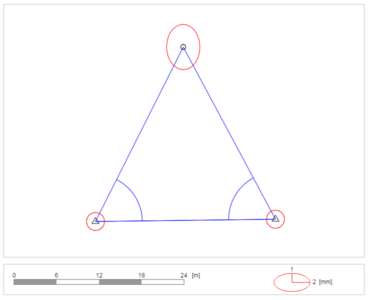
The measuring arrangement can be entered on the workspace using the buttons while the new point to be determined is already shown symbolized by a circle. Now any number of control points can be added by activating the button “control point” and clicking on its desired position on the canvas. Added points are able to be removed choosing the "Delete" function and then selecting the points to be deleted with the mouse. In addition, you can move every point to change the geometry of the measuring arrangement.
Adding observations works very similarly: activate "Distance" or "Angle" to add a distance or angle measurement. Use the mouse and click on the points between which the measurement is to be done.
After adding a sufficient number of measurements, the accuracy of the new point is calculated and error ellipses of all points are shown. By using the sliders different accuracies of the control points and measurements can be simulated.
Keyboard Shortcuts
p Add contol point
d Distance measurement
a Angle measurement Enter Cancel
c Delete control point
n Delete all
This tool uses: Numeric Javascript library (1.2.6), Sébastien Loisel, http://www.numericjs.com/
